Coal fields are defined by their geology and were mainly formed around 300 million years ago. They powered the Industrial Revolution in the UK during the 18th and 19th centuries and helped shape the country's industrial development over the last several hundred years.
As the decline of coal began in the 1970s, with further closures in the 1980s and 1990s, the last large-scale deep coal mine, Kellingley Colliery in Yorkshire, closed on 18 December 2015, signalling the end of the coal-mining industrial age in the UK. This was signalled by the closure of the last coal-fired power station in September 2024.
There is one small coal mine left in Wales and several small-scale artisanal mines left in the UK. The last opencast closed in 2023. The sector employs about 267 workers; a tiny number compared to the peak of around 1.2 million in the 1920s.
What is the Legacy of Coal Mining?
The coal mining legacy has left a history of unstable ground, risks from mine gases such as methane, carbon dioxide, carbon monoxide and hydrogen sulphide, contaminated soils and mine entries (known and unknown).
These can pose risks to land development, whether commercial or residential; they can be quite costly if not identified early in the process.
These maps show the extent of coalfields across the UK, along with the historic mining communities associated with them.
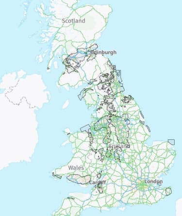
Credit to Mining Remediation Authority - Mining Remediation Authority Map Viewer

What can you do to mitigate these risks?
A desk study will indicate (if not already known) whether the site requires a dedicated Coal Mining Risk Assessment. This is the first step to understanding the legacy of any coal mining (or other mineral mining, such as ironstone or fireclay) in your proposed development site.
Coal mining risk assessment (CMRA)
At a basic level, the CMRA should have the following to help narrow down and define the risks to development:
- site history
- geology
- a mining report from the Mining Remediation Authority (formerly The Coal Authority)
- a summary of the mining risk with any known or unknown risks being highlighted for further assessment and/or ground investigation works
- areas mined (shafts or opencast) before the 1880s which are unlikely to have abandonment plans, but can be shown as old shafts on historical plans - the 1872 Mines Act insisted on abandonment plans
- bell pits were a common technique pre-industrial revolution and have a unique risk profile, typically up to around 8m deep
- other mining or quarrying activities are evident eg flagstone mining, ironstone, gypsum, lead or brine
- whether a mine gas risk assessment is required, including monitoring wells for groundwater.
The Mining Remediation Authority (and several other organisations with archives) have helped by digitising information to help with risk identification with the interactive Mining Remediation Authority Map Viewer.
Coal mining ground investigation
The results of the CMRA will confirm whether an intrusive investigation is required and if so, you should consider:
- mine entries – known and/suspected
- shallow workings <30m below ground level
- opencast workings – highwalls and what was it backfilled with, how deep is it
- groundwater monitoring wells
- mine gas monitoring installations.
Coal mining remediation and verification
Once the CMRA and ground investigation are concluded, recommendations should be made to remediate the issues to enable construction to commence.
These can include, but are not limited to:
- development layouts should consider the location and avoid the influence of mine entries or other influencing features
- grouting of mine workings on a grid pattern
- locating mine shafts, drilling and grouting with a cap placed over the shaft
- delineation of highwalls.
Once the work is completed, grout usually requires around 28 days of curing before any post-remedial monitoring commences.
Verification and validation of the works is essential and should be well documented to ensure that any future development is safe for the future homeowners.
Where to seek help
If you have a site in a coal mining or mining/quarrying area, contact a consultancy familiar and competent in coal mining geology and assessments, who will undertake a desk study and start your journey to understanding the risks.
NHBC Land Quality Service is dedicated to supporting developments facing land risks. By engaging with us early, you can submit your evidence or proposed solutions for expert review. We will provide clear advice on whether NHBC Land Quality Requirements are being met and if not, outline actionable steps to achieve compliance. Early derisking not only offers reassurance to investors and stakeholders but also helps prevent costly delays by identifying potential issues before they escalate, ensuring a smoother path to warranty approval.
Further reading
Useful guidance on this topic is available in CIRIA publication C758D Abandoned Mine Workings Manual and CL:AIRE Good Practice for Risk Assessments for Coal Mine Gas Emissions.
Talk to us
Speak to our specialists early to reduce risk, avoid delays and unlock the full potential of your land.
Latest articles

The risks housing associations face – and how to tackle them

Our commitment to supporting subcontractors

Decades of change: The evolution of our Building Control service
